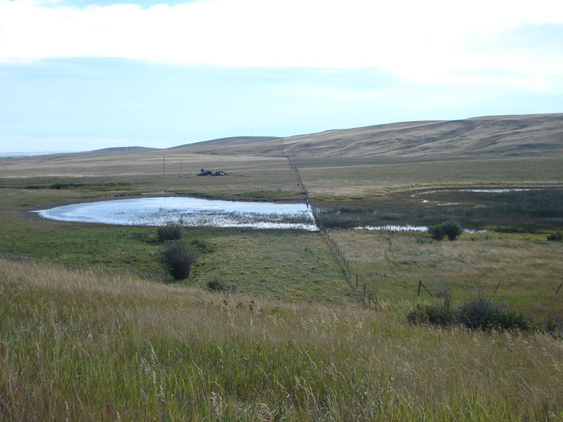
Montana Grazed Pothole Information
| Wetland Category: |
|
Fresh Marsh |
| NWI Classification: |
|
PEM1F(grazed) |
| Latitude: |
48.519774 |
|
Longitude: |
-113.073714 |
Image Data |
| Date: |
|
09/04/2010 |
| Direction: |
East |
| State: |
Montana |
| Country: |
USA |
| Location: |
Along US Highway 2 west of Browning, Montana |
| Author(s): |
Larry Handley |
| Affiliation: |
USGS/NWRC |
|
| 
09/04/2010 | | |
|
|
Description:
Palustrine emergent wetland with persistent herbaceous vegetation that has been grazed on the north side of the pothole. Water regime is semipermanent flooded because the pothole bed has been very shallow at some time allowing broadleaf cattails to colonize.
|
Conditions: Isolated wetland is a glacial pothole that has freshwater available most of the year in most years.
|
| Dominant Plants: |
|
Scientific Name: |
| Broadleaf Cattail |
|
Typha latifolia |
| Hardstem bulrush |
|
Schoenoplectus acutus |
|
|
Disturbances: Broadleaf cattails and Hardstem bulrush have been grazed off on the north side of the fenceline. |
|
Comments: Dependent on resolution of imagery and mapping scale, the pothole could be classified as two separate polygons: 1) PUBH (grazed)on the northside of the fenceline; and 2) PEMIF on the southside of the fenceline. |